|

 Abstract:
 |
Interior Tube: This is probably the most basic lava tube. These are like blood vessels in flesh, conveying the fresh lava to the flow front. These occur mainly in flood basalts, and seldom, if ever, become "caves," since they do not "drain out" the tubes. The fluid lava simply stops flowing and hardens like concrete poured into a pipe. |
| Surface Tubes: Small, individual lava streams sometimes crust over, and then drain to form lava tubes on the surface of the surrounding ground. These can sometimes be identified as ridges radiating from known eruptive centers. On Earth, these types of tubes tend to be small in size. Their Martian counterparts could well be much larger. | |
| Semitrenches: A Semitrench tube results from a lava overflowing a channel, which in turn builds up walls or "levees." If the flow continues long enough, a roof forms over the flow completing the tube. | |
| True Trenches: These kinds of lava tubes form from a continuous flow that "eats into" the surface, eroding it down like hot water flowing over ice. The walls of these tubes are composed of the surrounding native rock with a veneer of fresh lava as a glaze. | |
 |
Rift Tubes: These lava tubes offer the most
variety in shape and size, due to the fact that they are dependant upon
forces other than just the flowing lava. Rift Tubes form as lava flows
down an existing rift. As a result, the tubes take on attributes of the
rift itself. Many times, subsequent flows can pile up on top of one
another resulting in multi-level lava tubes. (Lava Tube diagrams after Harter & Harter 5) |
Eruption of Martian Data:
After Mount St. Helens came back to life, and the data from Mars started to accumulate, I was drawn to the vast volcanic areas of the Red Planet. The orbital views showed many of the same igneous landforms found here on Earth, with the difference being a matter of scale. The Martian features were much larger, and this included the lava flows and presumably the lava tubes as well.
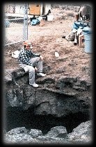
 The tubes are there, many being identified from the "skylights," (right),
of their collapsed ceilings. These tubes are considerably bigger than
their terrestrial counterparts. Since we have yet to explore the tubes
of Mars, we can only assume that their internal structure would be
similar to their Earth cousins.
The tubes are there, many being identified from the "skylights," (right),
of their collapsed ceilings. These tubes are considerably bigger than
their terrestrial counterparts. Since we have yet to explore the tubes
of Mars, we can only assume that their internal structure would be
similar to their Earth cousins.
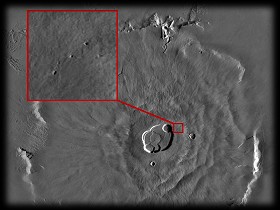
Many areas of Olympus-Mons for example exhibit many landforms that look like collapsed tube skylights. [VO Frame 47B25; 21N, 130W]
Along the Southeast flank of Arsia Mons, a series of well-defined tubes and channels are also visible, [VO Frame 52A04; 12S, 120W] as well as the sides of the Northern shield Alba Patera. [VO Frames 7B94; 41N, 109W and 7B53; 46N, 119W]
The relative elevation may eventually be a factor in locating this tube systems for future habitation. These range from the "low" 1 km of the Northern Alba Patera area upwards to 10 km and greater on the Tharsis shields. An elevation of "0 km" was defined as that elevation where mean atmospheric pressure at the surface is equivalent to the triple-point pressure of water, or 6.1 mbars.1 By comparison, my barometer here in Silverton, Oregon is at this moment reading 29.78 mbars. Silverton is at about 200 feet above sea level.
Logic dictates that many of the common features of terrestrial lava tubes would also be present in larger versions on Mars. What we would have would be long tubes of solid rock. It would be a relatively simple matter to build a colony in one of these tubes. It would be air-tight and would offer superior shielding against the raw environment of the Martian surface--its thin atmosphere and resulting exposure to the elements--solar flares, radiation, cosmic rays and the like.
In the second volume of his trilogy of the colonization of Mars, "Green Mars,"11 Kim Stanley Robinson located one of his rebel colonist groups within a hypothetical modified lava tube situated in the Martian Southern hemisphere, approximately 64S, 290W, in the Northern Dorsa Brevia region. In his scenario, the colonists blocked off sections of the huge tube with bulkheads of a pliable, airtight fabric.
A small dome was erected over one of the skylights to admit light, and the tube was partially flooded, creating a landscape of underground forests, fields, lakes and islands within this enclosed world. Expansion of the colony was achieved simply by moving deeper into the tube system. He sized his tubes using a 2-to-1 ratio created by the gravitational and other uniquely Martian conditions. NASA observations put the ratio at 10-to-1.13
His tube was wider than it's Earth kin by a factor of several hundred, and was 40 km long. This scheme closed off 12 km of the lava tube, divided into 1 km segments.
Robinson's tube system was apparently of a single flow. It featured only one main (albeit large) single tube. On Earth, and presumably on Mars too, multiple lava flows over-lap each other,12 sometimes creating lava tubes on top of older lava tubes.
In Ape Cave, this phenomenon is present. In fact, one such area is like a large "bubble" located above the main tunnel. By clambering up a side channel, and crawling through a narrow half meter-high opening for about 3 meters, one enters into a large domed chamber about 7 m in diameter and some 5 m high. (The last time I visited this amazing place thirty-some years ago, it had been vandalized by juvenile spray painters. A trade-off for making such exotic places easily accessible to the masses.)
The Cascade volcanoes including St. Helens are composite cones that alternately erupt silica-rich rhyolites as ash and flows of fluid basalt.
Tubes as Habitats and Reservoirs:
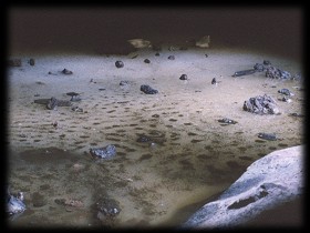
The Icelandic tubes I explored, tended to have little siltation. This no doubt being due to the fact that they were caused by fissure eruptions that tend towards flood basalts. One of the larger and more popular of the Icelandic tubes is Surshellir, a cave located east of Iceland's capitol of Reykjavik. Between 1752 - 1757, the King of Denmark, who then "owned" Iceland, commissioned a complete survey of this Northern outpost of Denmark, which was later published. While in Iceland, I purchased the then newly released English version10. In it, the authors describe in much detail, their passage through this cavern:"There is no doubt that this cave has been inhabited, not by giants but by vagabonds, who escaped to avoid punishment for their crimes, which is probable both from its situation and the following anecdote. In two of the ancient histories it is stated, that in the tenth century, a body of thieves took refuge here and found a safe retreat, because, from superstition, no person would approach the cave, and when they went out to commit their depredations, they had on one side a number of farms, and on the other the land of Arnarvatn, which was always covered with sheep and oxen at pasture. Several other tales are told of different bands of robbers, who have successively resided in this cavern, which have made such an impression on the minds of the people, that none of them will attempt to enter it.This last paragraph reveals another aspect of the Earth tubes: They tend to collect water. In fact, most of the lava tubes I have explored on Mount St. Helens have small pools of water at their ends. One tube is named "Lake Cave" for it's large "lake" that fills the end of it. Another, "Little Red River Cave," has a little stream running through its length. Of course, one also finds fine sandy floors of volcanic ash in places from the various "lahar" or mud-flows that have spilled down the mountain over the years.
"The entrance to the cavern of Surtshellir is gloomy, and runs from N. W. to S. E. but preserves its height, which is from thirty to thirty-six feet, while its width is from fifty to fifty-four. Its soil or bottom is uneven, sometimes rising, and at others falling; its partitions are the same, only that there is an equal distance between them. On advancing, it is perceived that the cavern turns to the south, and afterwards to the S. W. and W. in proportion as it diminishes in width.
"...at the end of this declivity, our travelers found a lake of fresh water, the bottom of which was frozen. They passed it with the water up to their knees, and at every step they had additional proof that the whole of these caves had been formed by the melting or dissolution of stones. The great channel being at length blocked up for some time, and the fire not being to able to find a vent, acted upon the sides, and melted the more dissoluble earths and stones; but before the fiery matter could thus find an outlet, the great canal had forced its way, and had ceased to have any action on the caverns."
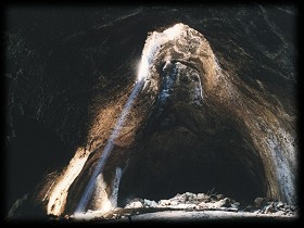
 In Central Oregon, this is even more pronounced. Many of the lava tube caves there have such names as "Arnolds Ice Cave," (right),
"Surveyors Ice Cave," and "South Ice Cave." These caves are not "ice
caves" but rather common lava tubes with seasonal, and sometimes
permanent ice deposits.7 What occurs in these caves is that during the
winter months, cold, sub-freezing air sinks into the cave's depths.
Owing to the surrounding basalt's superior insulating properties, the
air remains below 0 degrees C. When the spring thaw occurs, melt water
tricking into the depths of the caves encounter this cold winter air and
freeze out. Many times as spectacular formations of stalactites and
stalagmites of transparent ice.
In Central Oregon, this is even more pronounced. Many of the lava tube caves there have such names as "Arnolds Ice Cave," (right),
"Surveyors Ice Cave," and "South Ice Cave." These caves are not "ice
caves" but rather common lava tubes with seasonal, and sometimes
permanent ice deposits.7 What occurs in these caves is that during the
winter months, cold, sub-freezing air sinks into the cave's depths.
Owing to the surrounding basalt's superior insulating properties, the
air remains below 0 degrees C. When the spring thaw occurs, melt water
tricking into the depths of the caves encounter this cold winter air and
freeze out. Many times as spectacular formations of stalactites and
stalagmites of transparent ice.
Arnolds Ice Cave in fact was regularly "mined" for its ice, which was sold in near by Bend, Oregon during the warm summer months. These mining operations opened up the cave for the first time in many years, and allowed for its thorough exploration. After the advent of electric refrigeration, the ice miners were out of work, and the cave slowly started to refill with ice. Today, it is totally inaccessible, with only the top of the stairway built in the 1960s poking out of the top of the ice.
On Mars, we may also find water, frozen at the end of the tubes. These may in fact be huge natural cisterns. The tubes may well prove to be a good place to look for water. But where to look for the lava tubes? Robinson's Tube Colony was located in the ancient Southern flows. But examination of the Viking orbiter images, as well as those from the current Mars Global Surveyor, show lava tubes and features relating to lava tubes in a host of areas around the planet.6
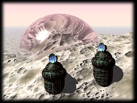
Building in the proximity of a skylight would allow for the "piping" of sunlight into the tube chamber. Robinson's Inflatable bulkheads could be created to block off large sections. An easier approach may be inflating a single, very large balloon within the hollow. This would be like blowing up a toy balloon within a cup. It would conform to the shape of the space, and provide a quick and easy habitable area.
Hornito Habitat:
 Another
feature of lava tubes on this planet are "hornitos." These are breaches
in the solid roofs of an active lava flow, which results in lava
spattering out of the holes. The lava soon builds up a "spatter cone"
around the opening, and can result in a "chimney" to the inner tube
after the flow stops. And unlike a traditional skylight sinkhole, these
openings do not have large rubble piles under them. Skylight Cave in
Central Oregon has three hornitos in its ceiling, which allow for
outside light to illuminate the interior.
Another
feature of lava tubes on this planet are "hornitos." These are breaches
in the solid roofs of an active lava flow, which results in lava
spattering out of the holes. The lava soon builds up a "spatter cone"
around the opening, and can result in a "chimney" to the inner tube
after the flow stops. And unlike a traditional skylight sinkhole, these
openings do not have large rubble piles under them. Skylight Cave in
Central Oregon has three hornitos in its ceiling, which allow for
outside light to illuminate the interior.A hornito habitat could provide a sheltered habitat complete with a natural light source and minimal excavation.
A Procedure for setting up Hornito Habitat might involve the following steps:
- Identify likely candidate lava tubes from orbit. Look for a series of skylight pits and spatter cones arranged in a linear pattern along lava flows.
- Establish ground contact; and do a preliminary evaluation of candidate tubes.
- Prepare the site. This may involve clearing some minor debris from the skylight cave-in.
- Install the deflated balloon. It would be constructed of a tough, insulated material. The portion where the skylight fits would be clear or translucent to allow for light transmission.
- Setup the balloon for inflation. This could be done either from supplied compressed air, or by the Martian atmosphere, with a "slow pump" sucking in Martian air over an extended period of time. (Plants could be introduced at a point to start converting the carbon dioxide into oxygen.)
- Once inflated, we move in! Establish an airlock, setup inner walls, partitions, etc.
- Communications antenna and solar power units would be setup outside, with the cables running down into the tube. With a hornito habitat, the domed-over hornito open would provide a light channel for illumination.
- A large protected habitable space could be setup in a very short period of time, maybe within 24 hours if one used supplied compressed air.
- The surrounding rock would provide an excellent radiation shield.
- The lava tubes might contain frozen water deposits.
- By deflating and moving on to other lava tubes, the colony could be semi-portable.
- Location-specific. The scheme would rely on the location of large lava tubes. This would exclude the majority of the surface.
- Lighting might be a problem. Locating directly under a skylight would help, but usually these areas (in terrestrial tubes) contain huge mounds of debris from the cave-ins that created the skylights. A better solution would be to locate caves with hornito openings.
- No Martian lava tubes have been explored, so we can only guess at this point as to their viability as shelters. I think it would be a good guess!
Oregon Moonbase
 The idea of making use of lava tubes has been explored by many others. The largest body of research I have encountered, comes from the Moonbase group of the Oregon L5 Society. This Portland-based space advocacy group is the Oregon chapter of the National Space Society, has been actively involved in this concept for over a decade, only focusing on lunar lava tubes rather than Martian ones. Between 1987 and 1988, a series of experimental bases were constructed by the group in Central Oregon2.
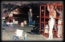 In conjunction with the Oregon Museum of Science and Industry, (OMSI) and the Oregon Young Astronauts, Oregon L5 contacted the City of Bend, Oregon and received permission for the use of Youngs Cave, a small lava tube within the city limits of Bend. They setup a temporary base inside the cave using inflatable structural beams.
The work of the Oregon L5 Moon Base team lead to several conclusions:
- Successful educational simulations of lunar lava tube bases can be run in lava tubes of central Oregon
- A lunar base simulation can be performed with personnel of minor age
- A permanent site would allow better simulations through use of an evolving base infrastructure on site;
- A full-time staff would improve organization, scheduling of activities, and data analysis
- Using a lava tube saves money, time, labor, and material.
There you have my flight of fancy. As I said at the onset, I do not pretend to fully understand all the intricacies of setting up a viable habitat on another world. But then again, you never know when some crazy half-baked idea might prove useful some distant day!
Thank you for taking the time to read this paper.
Gus Frederick
401 Silver Street
Silverton, Oregon 97381
E-Mail: gus [AT] marsunderground [DOT] org
Author's Biography (1999): Oregon native Gus Frederick, (DOB 10/4/54) lives in Silverton, Oregon with his 14 year-old daughter Genevieve. He works as Instructional Technology Specialist for the Oregon Public Education Network, is a member of the Oregon L5 Society, longtime Mars enthusiast and amateur spelunker, reads and writes science fiction in his free time and collects 78rpm jazz records for fun.
References:
- Batson, R.M., Bridges, P.M. and Inge, J.L., 1979. "Atlas of Mars." NASA SP-438, Appendix C: Contour Mapping by Sherman S.C. Wu, 131.
- Billings, T.L., Dabrowski, J. and Walden, B., 1988. Evolving Lunar Lava Tube Base Simulations with Integral Instructional Capabilities. Oregon L5 Society
- Carr, M.H. & Greeley, R., 1980. Volcanic Features of Hawaii: A Basis for Comparison with Mars. NASA SP-403
- Francis, P., 1976. Volcanoes. Penguin Books, London
- Harter, R. & J.W., 1979. Geology of Lava Tubes From NSSAC Geology & Biology Field Trip Guidebook. National Speleoogical Society, Huntsville, Alabama
- Hoges, C. & Moore, H., 1994. Atlas of Volcanic Landforms of Mars. USGS Professional Paper 1534
- Larson, C. & J., 1987. Central Oregon Caves. ABC Publishing, Vancouver, Washington
- Macdonald, G.A. & Abbott, A.T., 1970. Volcanoes in the Sea: Geology of Hawaii, University of Hawaii Press
- Mullineaux, Donald R. and Crandell, Donald R., 1962. Recent lahars from Mount St. Helens, Washington. Geological Society of America Bulletin 73, 855-869
- Olafsson, E. & Palsson, B., 1760. Description of the Cavern Surtshellirs. Revised English version published by Bokaut gafan Orn Orlygur Copenhagen 1975
- Robinson, Kim Stanley, 1994. Green Mars, Trade Edition, Bantam Books. Part 6 - Tariqat, 282-284
- Williams, Howel and McBirney, Alexander R., 1979. Volcanology, Freeman, Cooper & Co. Chapter 5, 106-109
- Various. 1976. Mars as Viewed by Mariner 9. NASA SP-329
- Oregon L5 Society Web Site: OregonL5.nss.org/